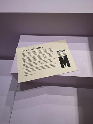
Your maplet - instructions
The Museum of Modern Art in Warsaw invites you to discover "The Penumbral Age" exhibition with the maplet.
The Maplet was created to make it easier for you to move around the space of the exhibition entitled “The Penumbral Age. Art in the Time of Planetary Change”. The map divides the exhibition into thematic “zones” and offers suggestions for questions that encourage an individual reception of the works of art. The map is intended to help you interpret the meanings of the artistic works and to stimulate reflection on the topics discussed in the exhibition.
Why did we create the map?
The epidemic in the spring of 2020 made it impossible for us to receive school groups at the “Penumbral Age” exhibition. We in the Education Department were looking for the best solutions to make the exhibition available and bring it closer to various audiences. We wondered what practical educational materials could be designed and created for the young people to explore the exhibition, if they would like to visit it individually.
At the “Penumbral Age” exhibition, the captions of the works contained information about the artist and the title of the work. A short curator’s text was placed at the entrance to the exhibition. The exhibition was accompanied by an extensive notes with the curator’s introduction and detailed descriptions of all the works. The map was conceived as an intermediate format between the brief and basic information available in the exhibition space in the form of captions, and the rich and comprehensive paper-guide.
For whom?
Initially, we thought about young people as the target group, but, while creating the map, we decided that it could also be a helpful resource for people of all ages. Ultimately, we tried to formulate the questions and select the level of language complexity so that the map was accessible to the widest possible audience.
What functions does the map have?
orientation in time and space: it helps you to plan your visit and pace yourself. The map estimates the number of works and their density, while also indicating the length of the videos.
inspiration: the map contains a number of open questions that encourage independent interpretation of the works, and, something that is extremely important to us, deep reflection on the topics discussed in the exhibition.
Open questions
For us –– the Education Department –– open questions are a very important tool in working with the audience (especially young people). Thanks to them, we treat the exhibition or specific works as a starting point for a conversation not only about art, but also about topics that art touches upon. In this way, we want to encourage an attitude of curiosity towards the world.
During educational classes, open-ended questions are our main source of knowledge about the interests of students/viewers, and they allow us to focus the lesson on topics that are particularly close to them.
Closed questions, on the other hand, steer the viewers to the topics we want to discuss, help them to interpret the work, and read the artists’ message. In the map, we focused on open questions.
The form of the map
The map was printed and offered at the Museum’s reception desk. It was also available for download in a PDF format (the QR code was provided at the reception; the map could also be found on the websites artmuseum.pl and wiekpolcienia.artmusuem.pl).
Due to the ecological themes of the exhibition, the paper version was regularly printed on ecological, black and white paper. People using the paper version were encouraged to leave it at the reception desk after the tour was over so that other people could use the same copy. This allowed for reducing the print run.
To further reduce the number of printed copies, we made it possible to access the map on a phone –– it was designed to also be legible and user-friendly on a small screen.
Map usability now
Although the exhibition “Penumbral Age” is over at the Museum on the Vistula River, the Maplet is still available on the websites artmuseum.pl (in the section Publications) and at wiekpolcienia.artmuseum.pl.
In addition, the exhibition itself can be seen at https://wnetrza3d.pl/realizacje/msn/wiek-polcienia-sztuka-w-czasach-planetarnej-zmiany-4000/.
The map can be used as an aid to “visiting” the 3D scan of the exhibition or as an independent material-source for inspiring questions on the subject of environmental awareness. It can stimulate reflection on global warming, and the management of irreversible phenomena, as well as threads of mutual solidarity and empathy. We think that it could also be a beneficial tool for high school teachers.
Inspirations for institutions
We hope that the map can be an inspiration for other museums and galleries to create educational, animating, and interpretative materials for exhibitions. We want to encourage people to go beyond the popular forms of exhibition materials (such as catalogs, worksheets, purely informative maps or fliers).
Our starting point was the visitors’ needs –– thanks to the information from the exhibition staff and the security people, we learned what information some visitors were missing (in the exhibition space) and we tried to find something that wouldn’t compete with the paper or the catalog, but instead, would complement or expand it.